A stroll along the GR7

Our 2012 winter project is to stroll along the GR7 on the section that runs through Granada province. The walk starts at Ventas de Zafarraya and finishes at Puebla de Fabrique. The total route is 408.3 km ( according to the Cicerone guide )

Friday, May 31, 2013

28 May 2013 Yegen to Mairena


Lunch in Mairena

We have not been out on the GR7 for 6 weeks, we have all felt a bit down, out of sorts, not wanting to have that feeling of failure again, when you fail to reach your objective. Last time we tried to walk a section of the GR7 Plym lost the car keys and we had to turn around.
Well, to be perfectly honest we have being off exploring other tracks for the last few Tuesday walks.
It was good to be planning another section of the GR7, initially the thought was we would return to Valor and walk back to Colco where we had to turn around last time but, after looking at the map and reading the guide book I thought it looked a bit uninspiring, especially as we had to do it twice, once on the outbound and then again on the return journey.
A new plan was hatched, we would go to Yegen and pick up the path from there, missing out some scrubland and road walking.  
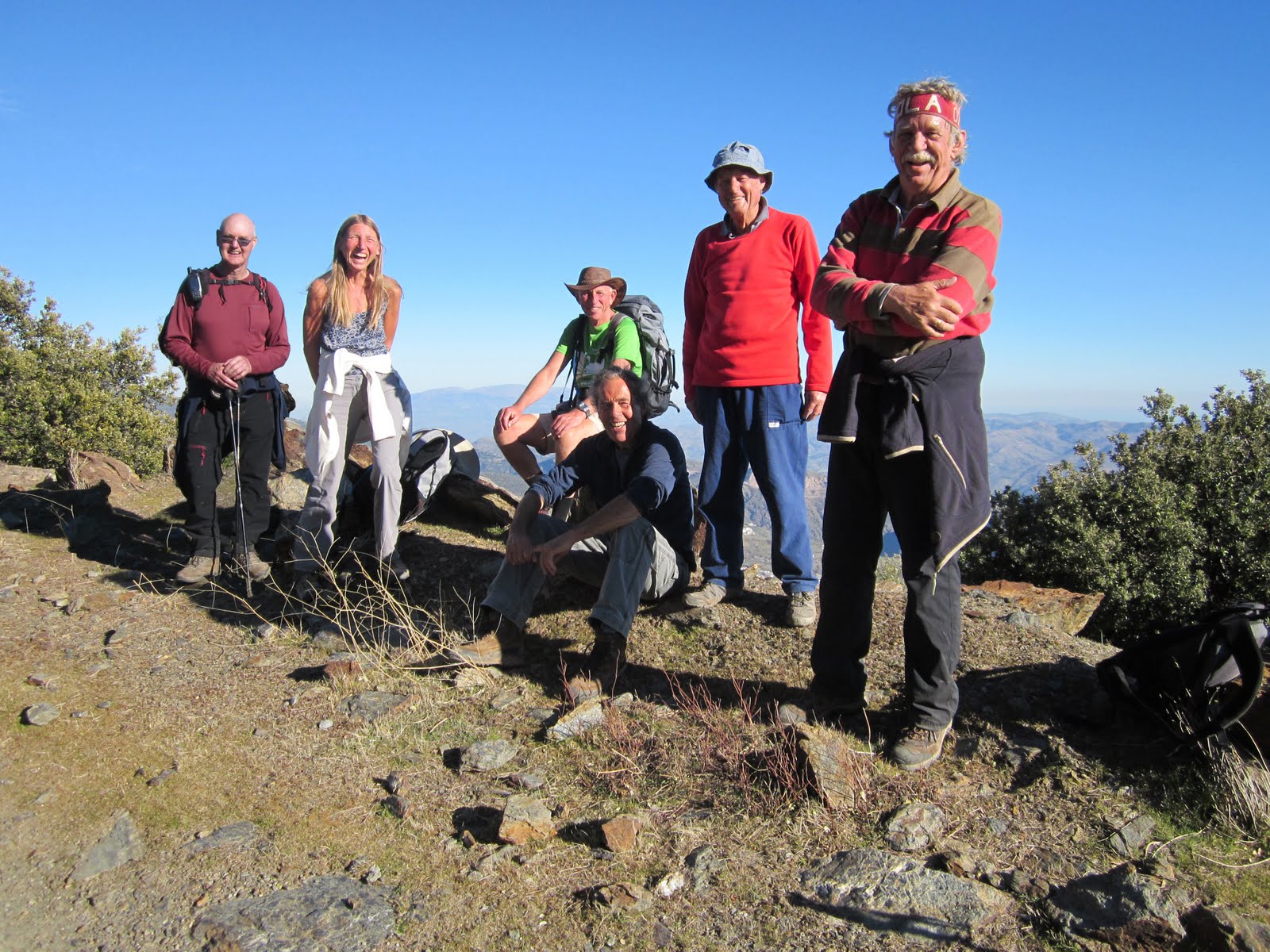
With a reduced group, there was only 5 of us this week, we set off again for the high Alpujarras and the pueblo of Yegen, made famous in the 1920s by Gerald Brenan the writer who lived and wrote about the area after the 1st world war. Goodness knows how long it must have taken to get up there in those days when there were only Mules and Donkeys and no roads. It is only 78 km but it takes 1.5 hours nowadays and that is not because of traffic jams, we only saw 5 cars the whole journey, it is just a slow road to drive along.  
We parked just outside Yegen, at a spot where the path left the road, and headed off across country. It dropped steeply down a narrow, flower filled barranco and it came out at a picnic area with a pretty carbonated water spring. It was a pity Julie was not with us, she likes to sample these natural waters.
As we neared Valor the path dropped steeply to a bridge that crosses the river. Could you get across, no. It was fenced off and there was a sign telling you it was dangerous. Could they have put the sign at the top of the hill, Yes! Back up the hill we went to join the main road into the village.
We stopped for a quick water stop in the village and Rene decided to ring her daughter in Australia, thinking it would be a quick call we hung about waiting for her to finish, 10 minutes later we decided to leave her and pick her up on the way back. Looking back we saw she was following, still on the phone.
We trudged uphill for 30 minutes, we could hardly draw a breath and Rene was still on the phone, goodness knows what she runs on, but it ain't oxygen.
The path continued alongside an acequia in and out of meadows, trees, and all the time the wild flowers, slightly past their best but still a treat to look at.
We had to drop down into Mairena, our turnaround point for the day. We had decided to not stop in the village but to retrace our steps back up the hill, stopping for lunch after the climb. When we arrived in Mairena we found a picnic site with tables, chairs and shade, what more could we ask for? Forsaking our vows never to climb a hill after eating we stopped and ate our sandwiches, and then climbed the hill on our way back to Yegen.
We stopped in Valor again, this time for an ice cream and then we were soon back at the car, all that was needed now was a friendly welcome and an ice cold beer at a local bar.
After visiting the bar in Yegen we need to come up with a new award. An award that recognises the effort which some people put into discouraging tourists to spend money. The Irish landlady of the bar in Yegan will be up amongst the winners, a truly memorable performance.  
We had a great day out, walking in some beautiful countryside and, with the thermometer hitting 25 degrees, the conditions were ideal.


On the walk Kees, Mike, Rene, Ray, Stuart.
Distance walked on the route today 10.1 km    Total distance on route 199.4 km
Distance walked today 20.3 km          Total distance walked 273.4 km
Height climbed today 866 metres Total height climbed 9534 metres
Distance driven today 156 km                      Total distance driven 1269 km

Thursday, April 18, 2013

16 April 2013 Alcútar to Mercina Bombaron


Who lost the car keys

This week we planned to do a 18 km section of the GR7 from Alcútar to Valor. There were 9 walkers up for the long day out on the hills and the weather forecast was excellent, at long last the clouds have gone and the sun has returned.
Because there was a large group we decided to take 3 cars up to Válor,leave one there, and then drive the 20 km over to Alcútar and walk back to Valor and then, drive back later to recover the cars. It would be a lot of driving on slow roads, but at least you don’t have to rely on taxis that don’t turn up or buses that leave early.
Because of the distances involved an early start was called for so we arranged to meet at 7.30 in Beznar.
Plym arrived with bad news, Mark had suffered an accident to his foot and was in hospital. A little dispirited we set off for Valor.
In Valor we found a convenient place to park Plym’s car outside a bar, ready for our return. We then drove up to Alcútar in two cars. By the time we got there it was coffee time so we walked up into Burchules and found a bar. Refreshed, we set off again up through the village and then down into a thickly wooded, steep sided valley. With all the rain we have had recently the trees and plants were bursting with life.
There were three brave walkers in shorts and plenty of Nettles and prickly bushes, I don’t know why they were hurling insults in my direction.
We have all learnt over the years that, when you go down into a deep barranco there is always a steep climb out, this was no exception. As it was a linear walk we could enjoy the descent and ascent in the certain knowledge that we did not have to come back this way.
The sign post had said it was 5 km to Mercina Bombaron, one of a number of villages we would be passing through today, but you can never trust them. By the time we got there we had clocked up 7 km. It was a glorious day and we refreshed ourselves in the village fuente. The village itself is on a steep hillside and we plunged down steep cobbled tracks, impossible to drive up, thank goodness we were only going down.
Continuing the downward theme we continued on a stony path down towards Colco, an isolated little publeo halfway down another barranco which we had to cross.
In the past we have had problems when we have tried to do what we were attempting to do today. The problems have always revolved around cars, specifically with the keys. We have arrived at our destination to find that the car keys are not with the driver, but are in another car 20 kms away. I don’t know what made Mike think about it but he said to me, “Do you think Plym has got the car keys with her?”
We have all come to know Plym as the sensible one within the group, never one for taking rash, impulsive or bonkers decisions. Of course Plym would have the keys, after all she was not carrying anything else, but I thought I would just mention it when I caught up with her.
She was slightly puzzled by my question, off course she had the key, and went to her pocket to prove it, then the other pocket, then the coat pocket. Then she accused us of having it. Reality slowly dawned, the key was missing.
We were now half way into our 18 km walk, with no way of knowing where the key was. It could be in the car in Valor, on the path we had walked on, the bar in Burchules or a car in Alcútar.
Graham, using his usual diplomacy, said it was always the Dutch who lost the keys until it was pointed out that the last time this happened it was he, himself who had dunit. Mike took exception to being classed as Dutch as he has also dunit. I owned up to losing the keys and phone on one walk, resulting in an extended walk home.
We had no option but to turn around and retrace our steps, keeping 8 pairs of eyes wide open looking for a key.
We stopped in Mercina Bombaron for lunch, this being the only place we had seen with some seats, at least it kept Dave happy. We then slogged it uphill and down dale all the way back to Burchules, stopping off at the bar for a quick beer and an enquiry after a lost key, no, he had not found it.  
Arriving back in Alcútar, there, on the back seat, having fallen out of her pocket, was the key. If it had not been there we were planning to make Plym walk the 80 kms home.

I thought Mike was a worthy candidate for a Brownie Point but the consensus opinion was no, It was only worthy of a mention in dispatches. I think there may be some tactical voting going on here.

A message from Plym
Just crawling out from under my rock of shame and degradation for a minute to offer you all my profuse and abject apologies and accept that my attempts at posing as an eminently sensible person are in tatters. Plym

It was a very enjoyable walk, taking us to new villages and on new tracks.

Mark will be out of action for a number weeks after losing an argument with an angle grinder.
   
On the walk Kees, Mike, Rene, Julie, Dave, Graham, Plym, Stuart.

Distance walked on the route today 8.3 km    Total distance on route 189.3 km
Distance walked today 17.6 km          Total distance walked 253.1 km
Height climbed today 889 metres Total height climbed 8668 metres
Distance driven today 200 km                      Total distance driven 1113 km

Tuesday, April 2, 2013

29 March 2013 Lobras to Alcútar


The crem de la crem picnic spot

We returned to Lobras this week to continue the walk as far as Alcútar. The path starts by heading down into a barranco that we have been in before when we did the GR142 last year. I must say this was a far easier way of getting there, I seem to remember spending hours wandering around the hillside last time, or perhaps my memory is playing up again.
The route then follows a delightful path that rises, then falls, to run alongside the Rio Cadiar all the way into Cadiar. We walked along twisting narrow streets on the edge of the town until we came to what looked like the old towns natural water spring, complete with a hand pump. Someone suggested it was time for a break and this made an excellent place to stop. I must say I excelled myself on this walk. This was the first of three stops, each one with comfortable seating. Another walk like this and Dave will be ceeding me his Brownie point, he does like a nice seat when he is taking a break.
I have to be nice to Kees this week so I won’t mention where Dave got his second hand Brownie point from. The walk continued by the side of the river and we took a small diversion to visit the Agua Agria, yes Rene, you were right with the translation of “sour water” but our experienced water taster Julie refused to check it out.
Retracing our steps we crossed the river on a rickety wooden bridge and then climbed up into Alcútar. We stopped here for lunch, once a again with a nice bench to sit on. We had walked around 10 km at this point so it was time to start heading back to Lobras.
We followed a series of paths tracks and country roads until we got to the acequia that runs into Lobras. After a short downhill scramble, or slither would be a better description, we joined the acequia path and then stopped for more refreshments at what must be the creme de la creme of picnic tables, it just doesn't get any better. After this it was just a short stroll back into Lobras.
The weather, apart from a few drops of rain, had remained fine all day but, on the way back, you could see it raining higher up. We stopped in Tozvizcon for more refreshments, it was so pleasant sat out in the sunshine we even stopped for a second round.
A very nice walk and well worth doing again.
On the walk Kees, Mike, Rene, Julie, Dave, Martine, Jan, Stuart.
Distance walked on the route today 9.6 km Total distance on route 181 km
Distance walked today 17.8 km
Total distance walked 235.5 km
Height climbed today 679 metres Total height climbed 7779 metres
Distance driven today 120 km
Total distance driven 913 km

Wednesday, March 20, 2013

19 March 2013 Juviles to Lobras


Our lunch stop above Juviles

Once again we have missed a few weeks on the GR7 because of bad weather, all this rain is starting to get to us now. It’s got so bad that this week, even though we knew it was going to rain, we were prepared to go out and get wet. Admittedly we thought we would only get a spot or two of light rain on the way back.
The route was going to be from the Trevelez area to Lobras, I say area because, like the last section into Trevelez, we have done the section out of Trevelez as part of the Sulayr path. So we thought we could give this bit a miss.   
The easiest way of doing this section was to drive to Lobras and walk along the GR7 towards Trevelez until we got to the part we had done before, and then turn around and walk back. A big advantage of doing it this way was that all the 1000 metres of climbing would be on the way out in the morning.
Lobras is a small sleepy village tucked away on the side of the Alpujarras, so sleepy in fact we saw no one either in the morning or when we returned in the afternoon.
We left the village on a newly restored path running alongside an acequia that the signboard said was the direct route to Timar, the next village along our route. The great thing about acequia paths is that they are virtually level, falling gently so that the water always flows downhill. We had only gone a couple of hundred yards when the GR7 and the acequia paths diverged, which was a shame because the GR7 path descended down into a steep sided valley. This only means one thing, a steep climb out of the valley, but hey, I had advertised the walk as having 1000 metres of climbing, so it gave us a chance to get a few metres knocked off. The sky were clearing and the temperature was raising and we thought we might be in for a decent day´s walking at last. The problem was we were only looking forward not behind us. Shortly afterwards we arrived in Timar, another tiny publeo nestling in the hillside. We stopped here so Plym could buy some buns from the local bread man and it was then that we noticed that the sky behind us was not the same as in front of us. In front we had blue sky and sunshine, behind the sky was black.
We had only been walking for 1 hour and nobody wanted to turn around yet so we decided to press on to Juviles, where we could find a bar and sit out any passing shower. The path was steep and rocky but it looks down into some spectacular deep valleys, well worth the effort and we did stop to help Plym eat some of her buns.
In Juviles the weather had not deteriorated any further so we decided to continue with the walk, all the time climbing. After another hour it became obvious that the weather was taking a turn for the worse, the temperature was falling and it was starting to rain and, ominously, the cloud cover was creeping down the hillside. A decision was wisely made to turn around and head back the way we had come.
We did manage to vary the route slightly, especially the way back from Timar where we managed to find the start of the acequia. This was a great way back to Lobras and it was on a path spotted by Kees, We had been walking down a campo road, when we came to a river flowing across it. The river was too wide to jump across and it was looking likely we would have to take our boots off and wade across, when Kees mentioned he had seen a bridge 20 metres downstream. I thought Kees deserved a Brownie point for this magnificient find if only for the fact that it kept our feet dry (well, I was OK because I had some plastic bags), but there was some disagreement within the group as to whether such a prestigious award should be made for finding a bridge, and this came from some of the ones who were going to get their feet wet. It just shows whatever you do someone always has to grumble. In the end it did not matter because it started to rain and we all got wet anyway, we just made it back to the cars when the heavens opened
   
On the walk Kees, Mike, Plym, Julie, Dave, Little Stuart, Stuart.


Distance walked on the route today 7.3 km    Total distance on route 171.4 km

Distance walked today 14.6 km          Total distance walked 217.7 km

Height climbed today 792 metres Total height climbed 7100 metres

Distance driven today 120 km             Total distance driven 793 km


p.s I am unsure whether Kees gets a Brownie point or not, so can you please vote on it. Bearing in mind he already has more points than anybody else anyway.


I have received a number of votes regarding the awarding of Brownie points but the results are inconclusive.


Votes countered so far


1 definitely yes

1 definitely but has not decided yet whether it is definitely yes or definitely no.
1 definitely yes from Kees, we might have to have a vote on this, because I think he might be biased.

This is not like voting LIB/LAB/CON

Your vote really does count and will make a difference

Hi
I know you are all eagerly awaiting the results of the vote but first can I say a few words about how I have complied them.

It was a bitterly fought campaign and the recriminations will linger for a long time. 

We had a spoilt ballot paper when someone voted for everyone to receive a brownie point. I think there must be a bonding issue here.

The bewildered has still not definitely decided. You can just imagine him keep switching lanes at work and before you know it the race is over.

One person voted twice, fortunately he did manage to tick the same box each time. This is not Africa where someone gets elected with 110% of the vote. So I have torn up one of his ballot papers.

Someone voted for himself, vote disallowed.

One unassuming person in England voted yes and got upset when someone said he was not allowed to vote

One little guy voted no and complained about outsiders being allowed to vote. 
One person voted yes and said it was down to Kees that she did not get really, really wet.
So with the votes countered we have an overwhelming 3 to 1 vote in favour of Kees receiving a Brownie point.

Thank you to everyone who took part in this truly democratic process.

Stuart

It now appears Kees was not entitled to a Brownie point at all, it was Dave who discovered the bridge. Kees has been striped of his award.


Thursday, February 28, 2013

26 February 2013 Portugos to Trevelez


Above Portugos


We have missed a couple of weeks on the GR7 due to poor weather at higher altitudes, choosing to walk down on the coast instead. With reasonable temperatures and clear skies forecast it was good to get back to our latest project.
The route should have taken us from Portugos up to Trevélez, but as it was only 13 km and the bus back would not be until 4 pm a new plan was called for. We have also done the last 3 km before, when it joins up with the Sulayr path. It was a section no one enjoyed because the path had been diverted due to a land slip. The diversion involved dropping down into a steep barranco, crossing the river on a bridge made from two sticks and climbing out again, but last year Plym reported you could now get through. Not doubting Plym’s word, well maybe a little bit, we thought it might involve a death defying scramble, so the plan was, we would go and investigate what had happened to the path.
For the last few years Mike has taken to carrying a thermometer, he has had various ones over the years, all from the Chinese shop and costing €1. The problem is they always read the same, 21 in the summer and 12 in the winter, we never knew whether to wear a woolly hat or a sun hat. Well, now he is armed with a state of the art portable weather station and it was reading 7 degrees when we started our walk from Portugos, so definitely a woolly hat and gloves walk.
We set off on a short path through fields before it comes out at the famous mineral water spring of Agua Agria de Pórtugos. People travel for miles to sample this natural health drink, known throughout Spain as an elixir of life. Julie, who is suffering from a Tennis elbow was keen to take the water, I suggested she try the middle tap on the basis that the elbow was in the middle of the arm and each tap has specific properties. This advice was freely given and based on sound scientific thinking, how was I to know it was the emetic one, but of course the stomach is in the middle of the body. I don’t think it helped her that we were all wetting ourselves laughing. We then crossed the road to look at a fantastic rust coloured waterfall, well worth a visit and now you know what the water tastes of.
Resuming our walk, the path starts a long 8km climb through a holm oak forest on a superb undulating path, eventually coming out on a forest road which we followed as far as the land slip. I am pleased to confirm Plym’s findings, there is now no problem using this route to Trevelez. This was our turnaround point and lunch spot before heading back on a different route to Portugos. The path down was not well used but it was way marked, and it will make a good Sunday walk later in the year. The weather remained cold but fine all day with Mike constantly telling us the temperature every time it went up or down .1 of a degree, the 7 degrees at the start was a high point.
Back in the village we stopped for beer and tapas, we could have stayed longer in the bar but we wanted to get outside to warm up a bit.  

On the walk Kees, Mike, Rene, Julie, Dave, Stuart.

Distance walked on the route today 10.3 km    Total distance on route 164.1 km
Distance walked today 19.3 km          Total distance walked 203.1 km
Height climbed today 712 metres Total height climbed 6308 metres
Distance driven today 80 km             Total distance driven 673 km


Wednesday, February 6, 2013

5 th February 2013 Pampaneira to Portugos


The highest spot on the level track

The next section from Pampaneira to Trevelez looked like it was going to be too much to do in one day, 25 km and 1400 metres of climbing. This sort of distance and climb is no problem for us, after all we are the A team, this would be just a stroll in the park. No, the problem would be getting to Trevelez in time to catch the 4 pm bus back. We had the same problem when we did the Sulayr walk, we arrived in Trevelez with one minute to spare, you can’t push your luck too far.
A new plan was drawn up, we would do a circular walk going out as far as Portugos and then returning on a higher level forest track. A quick estimate of the distance and height gain came out at 20 km and 600 metres. Perfect, and easy to sell to the team. Perhaps a little more time preparing the estimate would have come up with different figures.
We drove up to Pampaneira and by the time we got there Martine was looking a bit grey and feeling a bit off, it´s not the best road to travel on. To aid her recovery we opted to go to a bar for coffee.
The first part of the walk goes straight up through the village and on to Bubion. We had planned to do it last week but could not face the climb after walking from Lanjaron. It was not exactly easy doing it first thing in the morning either. After Bubion the path continues to climb, but at a more acceptable angle. This was a great hillside to wander about on, and we will have to come back and explore it some more. We then dropped down into Capilerilla, not to be confused with its bigger brother just a few kilometers away. Continuing with the downward theme we arrived in Pitres. Last week Mike would not let us stop for a beer, this week with the sun beating down and with a very pleasant plaza to sit in, he kept stum, so we stopped.
Worryingly the path continued downhill before crossing the rusty coloured Rio Charrera. You then have to regain your height back up into Portugus. We stopped here for a little lunch, it was our turn around point of the day but we still had 350 metres of climbing to do to get to a high level track that would take us back to the Porqueira gorge.
Mike has bought a new toy, it’s a pulse monitor, it was only reading 109 as we started the climb. The instruction book says it is safe for a man of his age to go up to 145. In an effort to check it out  three of them set off like a ¨Bat outta Hell,¨ I kept expecting to hear the monitor saying “he’s gonna blow, Captain”, they were doing 6 km/h uphill. They left Mark and Jan trailing in the distance, which they only managed to recover by cheating, by cutting corners in an effort to get to the front, no moral fibre the pair of them.
Once at the top we stopped for another lunch and Mike, happy to be alive after his sprint, was wondering around when he came across a broken sign post. It was just like having his own GPS, he could take it with him, he could point it in any direction he wanted to go.
A little bit of confusion now crept in as to how level the route back would be, I had described it as a high level route but I think some of the group misunderstood this to mean it would be a level, high route. It’s quite extraordinary how confusing English can be sometimes. Which might explain why Mark has to keep stopping when he is talking to our Spanish friends. He is just making sure they fully understand what he is saying. I think it is a load of bollocks, he just can’t walk and talk at the same time.  
When we got to the end of the levellish track, it only climbed 169 meters in 4 km we were high above Capileira. The map shows a track going straight back to Bubion but we could not find any sign of it, even asking a local did not elicit any useful information. Not wanting to risk exploring the hillside in the late afternoon  we stuck to the road through Capileira and Bubion before the steep downhill path into Pampaneira and the bar.
Oh that beer tasted good and it was getting dark as we headed off back in the cars. A beautiful walk, most of it in unexplored country and perhaps, or  maybe, a little longer than advertised.      

On the walk Kees, Mike, Martine, Jan, Mark, Stuart.

Distance walked on the route today 9.3 km    Total distance on route 153.8 km
Distance walked today 26.3 km          Total distance walked 183.8 km
Height climbed today 1220 metres Total height climbed 5596 metres
Distance driven today 74 km             Total distance driven 593 km

Wednesday, January 30, 2013

29 January 2013 Lanjaron to Pampaneira


Lunch stop in the Rio Chico

We have been doing some lower level walks for the last couple of weeks or so because the weather had turn cold, being old and decrepit cold weather does not suit us, but with the prospect of warm sunny weather, we decided to return to our big walk.
The next section was from Lanjaron to Bubion and, according to the guide book, it was 20 km. We would entrust our return journey to Alsina Graells, the local bus company. We could always stay overnight in Bubion if the bus did not turn up.
We met at Beznar for the drive to Lanjaron, right from the start it was clear that Kees was not right. Apparently Queen Beatrix of Holland decided to abdicate last night without consulting him. He had also set his alarm clock wrong and had dashed out without breakfast. We did offer to stop for toast and coffee in Lanjaron before we set off, he declined, and we were stuck with a bear with a sore head all day.
We have tried to do a section of this walk before and had to turn around because of a sticky section near Cañar. Mike knew what the rope sticking out of my rucksack was for but little Stuart was somewhat alarmed.
The walk is a series of climbs and level sections and calls in at various villages along the way as it meanders along to Bubion. We made good progress for the first 5 km until we came to the tricky bit where the path had fallen away a few years ago, why the major route through the Alpujarras is not maintained better I don’t know. With a bit of persuasion, judicious use of the rope, and some sterling work by Kees, who shepherded Mike and Stuart across the rough section, we were soon on our way again.
It was suggested that a quick beer in Cañar might help us on our way but Mike would have none of it. He was fired up after the landslip and wanted to keep going. We stopped for lunch by the side of the Rio Chico in a shaded glen for lunch, and then followed the acequia as it flowed down towards Soportújar. Once again the same old discussion erupted about water flowing uphill, this has been going on for years and no amount of reasoning can persuade the doubters of the implausibility of their argument. This week science was on my side, Jan is a nuclear scientist and if a man knows how to make an atom go bang he would certainly know that water only flows downhill. Even with his expert knowledge we still did not win the argument. We would have stood a better chance convincing them the world is flat.
In Soportújar the possibility of a beer was raised again, once again Mike vetoed the idea, you would think we had a bus to catch. The path continued onwards and upwards passing numerous cortijos by the side of a delightful path.
The climb up into Pampaneira is a trial, coming as it does after 18 km, our intended destination Bubion, was still half an hour away, uphill all the way. Pampaneira is a beer drinker's paradise, it is full of bars. Finally Mike said Yes we could stop, we could also catch the bus from here. Bubion will have to wait till next week. We even had time time for two glasses of the amber nectar whilst we waited for the bus, which fortunately did arrive this week, even though the driver would not stop at the bus stop we wanted in Lanjaron, making us walk an extra half km.

On the walk Kees, Mike, Martine, Jan, little Stuart, big Stuart.
A note for the records, Kees is awarded one Brownie point for services to wobbly knees.
Distance walked on the route today 18.9 km    Total distance on route 144.5 km
Distance walked today 19.5km          Total distance walked 157.5 km
Height climbed today 1064 metres Total height climbed 4376 metres
Distance driven today 20 km             Total distance driven 519 km